It is well known that Corfu is not only its beaches and coasts, where we usually hang and stay.
But it hides a lot in its interior, from picturesque spots, traditional large villages, Exceptional nature with high mountains and valleys where the vegetation revels, plains, sandy deserts such as Halikounas, even medieval villages that have been abandoned centuries ago such as the mountainous Old Perithia on the slopes of Pantokrator mountain.
Corfu, in spite of all the problems it faces, will always survive as a strong tourist destination because it has many more than other islands.
It has a turbulent and rich history, as a result of which its unique culture, as well as unprecedented unique natural beauties, despite its small size it is a continent in miniature, with so many variations in landscapes that make it look larger.
Watch this 35 minutes video of beautiful beaches, known and familiar destinations, but also many unknown small villages in the island’s interior that look like hidden treasures.
Corfu, without any special effort, will always be the flagship of Greek tourism!
The video was created by Petros Kapsokavadis on behalf of Oasis hotel in Perama, Corfu.
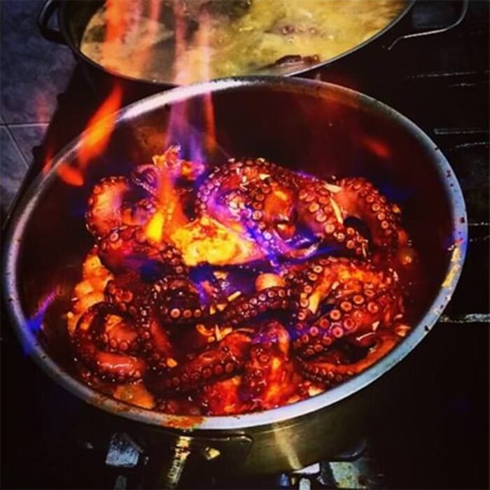
Bourdeto with octopus is one of Corfu’s most iconic dishes – fiery, aromatic, and deeply tied to the island’s fishing tradition.
For generations, local housewives and fishermen have perfected this spicy octopus stew, simmering it slowly with olive oil, pepper, and lemon until the flavors are bold yet balanced.
It is a dish that captures the heart of Corfiot cuisine.
Octopus Bourdeto – spicy and authentic
Ingredients (serves 4–6)
1 medium or large fresh octopus
1 glass white vinegar
1 glass extra virgin olive oil (250–300 g)
½ teaspoon hot red pepper
½ teaspoon sweet red pepper
1 large onion, cut into quarters
4 large potatoes, sliced
50–70 g fresh lemon juice (the secret to perfect flavor!)
Note: Do not add salt – octopus naturally contains enough.
Instructions
In a pot, heat 3–4 glasses of water with the vinegar. Briefly add the octopus, then remove and cut it into pieces.
In another pot, sauté the octopus on low heat until it releases its natural juices.
Add the olive oil, hot and sweet red pepper, onion, and enough water to cover the octopus. Simmer until most of the liquid evaporates.
Add the sliced potatoes and a little more water. Continue cooking until the sauce is nearly reduced.
Finish with the fresh lemon juice, stir well, and cook for one more minute.
Some Corfiots prefer it slightly juicy, while others – especially when serving as a meze – let it reduce almost completely, leaving the octopus coated in rich, spicy olive oil.
Tips for Perfect Octopus Bourdeto
Tenderize the octopus: Traditionally, fishermen beat it against rocks by the sea, then rub it for 30 minutes to keep it soft. If that’s not possible, freezing works as a modern alternative.
Choose wisely: Fresh octopus is best, but frozen local octopus works too. Avoid large imported ocean-frozen ones, which can be tough.
Texture & color: The final dish should have a deep red hue from the peppers, not black. The sauce is slightly oily, and the tentacles remain intact.
Serving Suggestions
Serve with fresh, crusty bread to soak up the rich sauce.
Pair with a bold Corfiot red wine or a crisp white for balance.
Enjoy as a main dish with potatoes, or as part of a meze spread alongside olives, cheese, and local salads.
Frequently Asked Questions
Is Bourdeto always made with octopus?
No – the classic Bourdeto is made with scorpionfish, but in many Corfiot homes, octopus is a beloved variation.
How spicy is traditional Bourdeto?
It is meant to be bold and peppery, but you can adjust the heat by reducing the hot red pepper to your taste.
Can I prepare it in advance?
Yes – Bourdeto actually tastes better the next day as the flavors deepen. Just reheat gently before serving.
Discover more authentic Corfiot recipes and explore the rich food culture of Corfu.
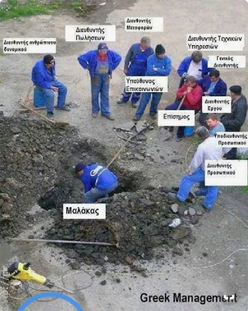
Most foreigners are told that “malakas” is a rude Greek insult meaning “wanker’, “jerk,” or “idiot.” But ask any Greek, and you’ll hear many different stories — some that include laughter, friendship, and even affection.
In truth, this single word is used everywhere in Greece, depending entirely on how, when, and to whom it’s said. It’s not just swearing — it’s culture. Let’s set the record straight.
But let’s be real — you’ll mostly hear this word from kids and young people. As you get older, it shows up less and less. In many ways, it’s a piece of youth culture more than a lifelong habit.
What does malaka(s) mean in Greece?
“Malaka” is probably the first Greek slang tourists hear. You’ll catch locals tossing it around casually, and it can sound either friendly or aggressive — context is everything.
The word means “masturbator.” But the modern usage is far more nuanced. Depending on tone, it can mean:
Insulting: wanker, jerk, asshole, idiot
Affectionate: buddy, dude, mate
Frustration: at politicians, the media, or just life
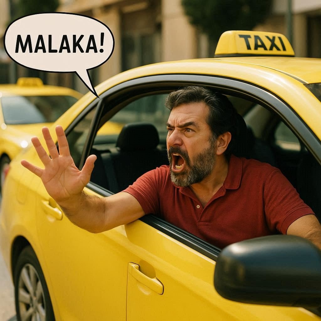
Malaka taxi driver
Let’s put it straightforward, this word is not only for idiots.
“Malaka” is a Greek word that can sound offensive, but its meaning depends entirely on context. Among friends, it might be a casual “buddy” or even “mate”. When aimed at someone you truly dislike, it becomes much harsher, conveying insults like “jerk”, “asshole”, or “motherfucker”. In moments of contempt or irritation, it can also mean “wanker”, “idiot”, or “stupid”.
And don’t worry if someone calls you that, even the gods of Greek mythology, in their stories, weren’t immune to foolish mistakes. See? It’s not that complicated!
🚫 When not to use Malaka(s)
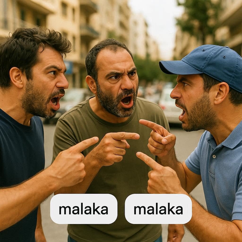
Three Malakes agruing
Alright, let’s decode the “Malakas” enigma and keep your nose unbroken, shall we? Buckle up, language explorers, because this is the Greek word maze you don’t wanna wander into without a map!
“Malakas” is like a sassy pet dragon – sure, it can be fun, but sometimes it might breathe fire when you least expect it!
Here’s the ultimate guide to navigating the “Malakas” minefield:
Rule 1: Gender Alert!
Ladies and gents, whether you’re crushing or cuddling, never toss “Malakas” like confetti. If you’re a guy, don’t say it to a gal – it’s like handing her an insult-wrapped bouquet. And hey, gals, same rule for the dudes – calling them this is like gifting them a not-so-shiny dunce cap.
Rule 2: First Impression Blues
Hold onto your hats, folks. If you’ve just met someone and think “Malakas” is a fancy icebreaker, hold that thought. It’s an icebreaker all right – for breaking the bridge between you two!
Rule 3: Stranger Danger
Think that you’re walking down the street, and a wild “Malakas” escapes your lips to a stranger. Whoosh! Brace yourself for a tsunami of trouble. Expect weird stares, raised brows, and a sudden urge to hide behind a lamppost.
Rule 4: Respect Your Elders
When it comes to seniors, the “Malakas” ship has sailed. Avoid saying it to folks who’ve seen more birthdays than you – grandparents, uncles, aunts, the whole shebang. Calling them this is like shouting, “I skipped the manners class!”
Rule 5: Sibling Shenanigans
Brothers and sisters, get ready for a plot twist! It’s all chill to drop “Malakas” bombs on your siblings – unless you’re in the middle of a tiff. Yup, even Greek siblings know when to holster this word.
Rule 6: Never use it when you drive
Have you ever seen Greek drivers fighting in the middle of the road after an accident?
It can be quite entertaining, and the cause might not even be the accident itself.
Instead, it could be because one driver called the other ‘Malaka,’ which in this context means ‘idiot,’ ‘incompetent,’ ‘stupid,’ ‘blind,’ ‘can’t you see, you crook?’, ‘did you get your driver’s license at night?’… and all those polite, cosmetic adjectives.
Rule 7: The Greek Riddle
Listen, only Greek Jedi Masters can decode all the secret “Malakas” handshakes. For the rest of us mere mortals, stick to the golden rule: avoid it like a haunted house on Halloween.
So there you have it, language adventurers – a guide to avoiding “Malakas” mishaps. Remember, it’s like a spicy hot sauce – a little can add flavor, but too much will leave you in tears!
✅ When you can call someone Malaka
Hold onto your Malakas hats, folks, because we’re diving deep into the labyrinth of Greek slang!
Saying “Malaka” in Greece is like wearing a secret friendship ring – it only works with your inner circle!
Expressions like ‘ela re malaka‘ (come on Malaka). or ‘na malaka‘ (take them Malaka), or ‘eise enas Malakas‘ (You are such a Malakas), etc… are always welcomed between friends!
But If you’re not exactly BFFs with someone, using this word might unleash the eyebrow raise of doom, after all, is not so polite to call ‘wanker’ a stranger.
Rule 1: The Close-Call Code
You and your pal, both hands on your secret decoder rings, crack a sly smile and drop a casual “Malaka.” Voilà! It’s like saying, “Hey, buddy” or giving a super-secret handshake – the kind that’s part cool, part code.
Rule 2: Sibling Shenanigans
Do you have brothers and sisters? Well, congrats, you’ve got a Malaka pass! Brothers can fling it, sisters can sling it – as long as they’re not in the middle of a sibling showdown.
Rule 3: The Multiverse of Malaka
Brace yourselves for a plot twist, linguists – “Malaka” has more layers than an onion. It’s the Swiss Army knife of Greek slang, with a gazillion uses. But here’s the twist: it’s like the word “run.” You can run a marathon, run errands, or run late – but it’s still just “run.”
Rule 4: Friend or Foe?
This word is like a secret weapon in a superhero’s utility belt – it can mend or break bonds faster than you can say “Malaka!” Imagine saying it to your pals and sparking laughter. But with strangers or even casual acquaintances, it’s like showing up to a costume party dressed as a question mark.
Why “Malaka” vs. “Malakas”?
If you’ve seen both malaka and malakas, don’t worry—it’s the same word. It’s just Greek grammar.
In the nominative case (the “dictionary form”), we say ο μαλάκας → “the guy.” That’s why you see the -s at the end, especially in URLs or word lists.
In the vocative case (when calling someone directly), the -s drops: μαλάκα! → “Hey malaka!” This is the way Greek grammar changes the endings.
👉 In English, there’s no difference, because English doesn’t really use cases anymore. But in Greek, that little -s tells you whether you’re talking about someone or calling out to them.
But Why Do We Hear This Word So Frequently in Greece?
The word has evolved into a kind of social Swiss army knife. In a country where frustration with institutions, politics, media, and even daily life is deeply rooted, malakas became a default expression of anger, irony, solidarity, or just fun.
Below is a simplified board that shows just a few of the types of people or behaviors that Greeks might refer to with this one word. It’s not always logical. But that’s the point:
The ‘Malakas’ Board: Who Gets the Label?
Who/What
Why They’re a “Malakas”
Politicians
Because they lie, steal, or serve personal agendas
Journalists
Often seen as puppets for the government or oligarchs
Mass Media Owners
They fund propaganda, distort the truth, and profit from misinformation
The People
For tolerating all of the above, without reacting
Bad Drivers
Cut you off, ignore rules, then curse you instead
Friends
Yes — sometimes affectionately, like “you idiot, I love you”
This is the paradox of malakas: a vulgar term that’s become a mirror of Greek society. It doesn’t just mean “wanker” anymore — it can mean almost anything depending on tone, mood, or moment.
So next time you hear it in a Greek taverna or from a passerby, don’t take it personally. It might be an insult — or a compliment. Or just part of the music of everyday life.
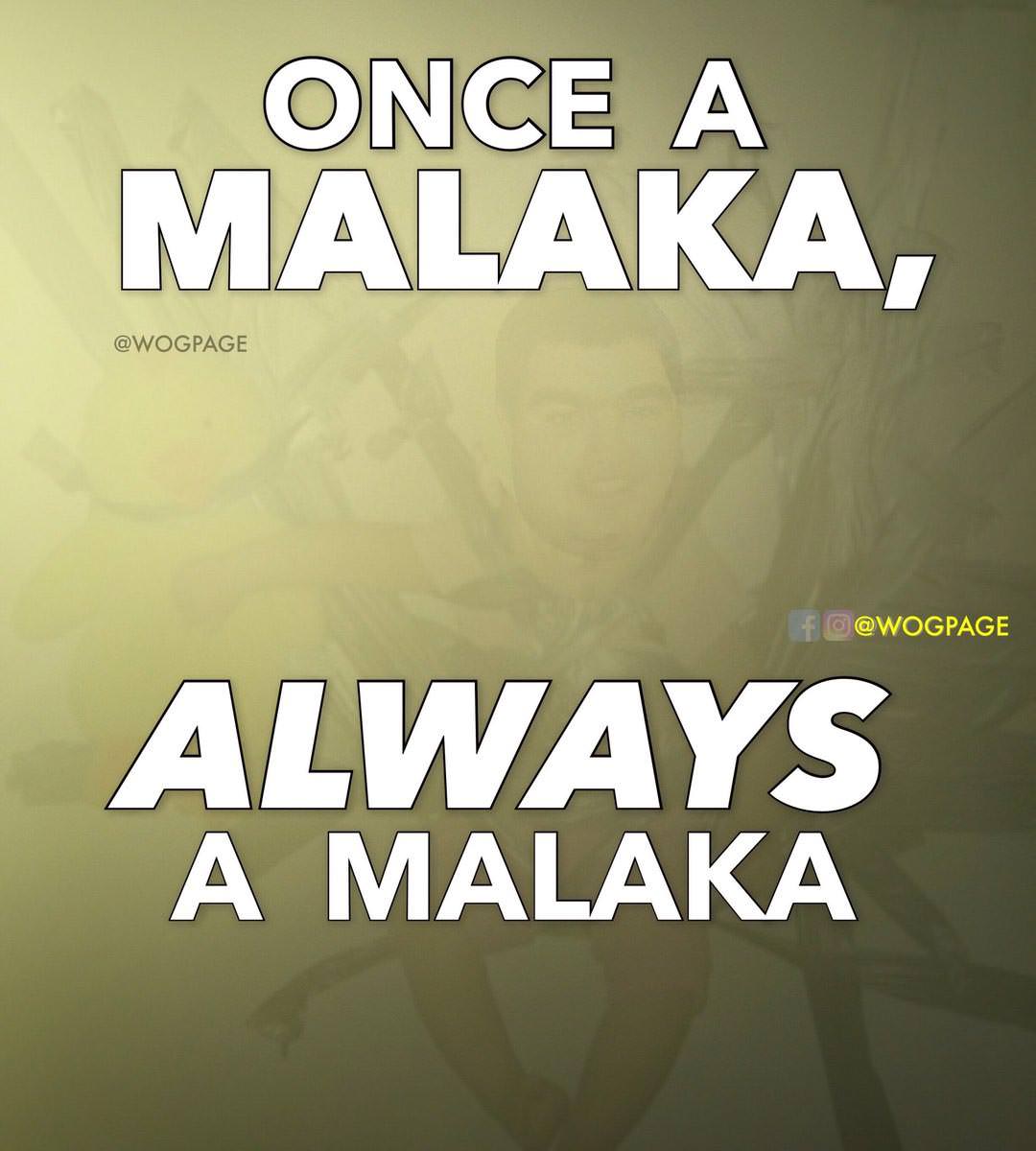
Once malakas always malakas
Other Today’s Meanings
Alright, folks, let’s dive into the enchanting world of “Malakas,” where meanings swirl around like a Greek salad at a party!
The Masturbator, since the Middle Ages, was considered the Idiot and everything around it, and still is.
And a masturbator’s synonym is the famous Malaka(s). We mean a person who’s the king or queen of cluelessness. You drop a hint, they miss it by a mile. Are people teasing them? They’re like, “Huh? What mocking?”
Meet the champ of misunderstanding, the grandmaster of being fooled. Yep, it’s like they’ve got a secret talent for turning simple conversations into a game of verbal twister!
Now, drumroll, please… let’s unveil the real deal: “Malakas” translates to the MVP of IQs that decided to take an extended vacation. Think about it – if brainpower were a rollercoaster, they’d be on the kiddie ride!
In the wild jungle of social circles, at work, or wherever minds mingle, “Malakas” is like a neon sign pointing to the low-IQ club. It’s the universal signal for “Hey, we’ve got a live one here!”
So, there you have it, folks: “Malakas” = Master of IQs lower than the average. It’s like calling out someone’s brain cells for playing hooky.
Just remember, the next time you hear it tossed around, it’s like a secret handshake for the IQ-challenged squad!
Greek workshop – Only the asshole works
Why Do Friends Say “Malaka” to Each Other?
Among close friends, it’s not only tolerated — it’s expected. You’ll hear phrases like:
“Ela re malaka” – Come on, man
“Eisai enas malakas” – You’re such a goof (with affection)
Think of it as a Greek badge of trust — but only in familiar company.
Arkas – Behaving as Malakas
Origins of the Word Malakas
Historically, “malakas” comes from “malakia,” meaning softness or weakness. In medieval times, masturbation was linked to mental decline — so the term gradually evolved into a general insult for fools and weaklings.
But Greek culture is flexible. The same word can now carry irony, affection, or contempt — depending on the speaker and the moment.
So… Is “Malaka” a Bad Word?
Yes and no. It’s vulgar in literal meaning, but softened by social context. Greeks use it like seasoning — sparingly or generously, but always with intent.
So, unless you’re sure of the mood and your relationship with the person, keep it in your linguistic back pocket. Use it wrong, and you might get silence. Or worse — a slap.
Visiting Greece? You’ll Hear It. A Lot.
Especially in casual settings, such as cafés, beaches, and traffic jams. It’s cultural shorthand. Don’t try to master it — just observe and enjoy.
But wait, Malakas is just the tip of the iceberg; there are thousands more swear words in Greek that you will definitely enjoy!
Tourist Tip – Can Foreigners Use It Safely?
If you’re an English-speaking adventurer hoping to bond with the locals, chances are you’ve already heard malaka tossed around like confetti. The good news? Tourists usually get a free pass — think of it like an amusement park wristband. But fair warning: there’s always a tiny risk of stepping into friendly fire.
Heading to Corfu? Don’t be surprised if Malaka pops up in cafés, on beaches, or from a smiling driver stuck in traffic. Around here, it’s often more playful than rude. Use it with care, and you might just pass for a local (or at least make someone laugh).
Bottom line: Malaka is like a secret handshake — it can open doors or accidentally start a duel. Unless you’ve cracked the code, it’s probably smarter to keep it in your back pocket. And hey, when in doubt, focus on pronouncing moussaka properly — fewer risks, more rewards.
Final Thoughts
“Malaka” is more than slang — it’s a window into the Greek psyche. It’s about emotion, timing, and relationships.
And yes, here in Corfu, we might just say it more than anywhere else. But don’t worry — if we call you one, it might mean we like you.
Want more? See real-world examples from Greece, England, and France here:
So, buckle up, fellow adventurers, because the world of “Malakas” in Malaka’s country is just a click away.
And remember, when in doubt, embrace the spirit, the slang, and the unforgettable journey that comes with it. It’s all part of the glorious Greek experience, Malakas-style!
Excuse our lack of good sources, but who needs sources when an original Greek, malaka writes this post? Right?
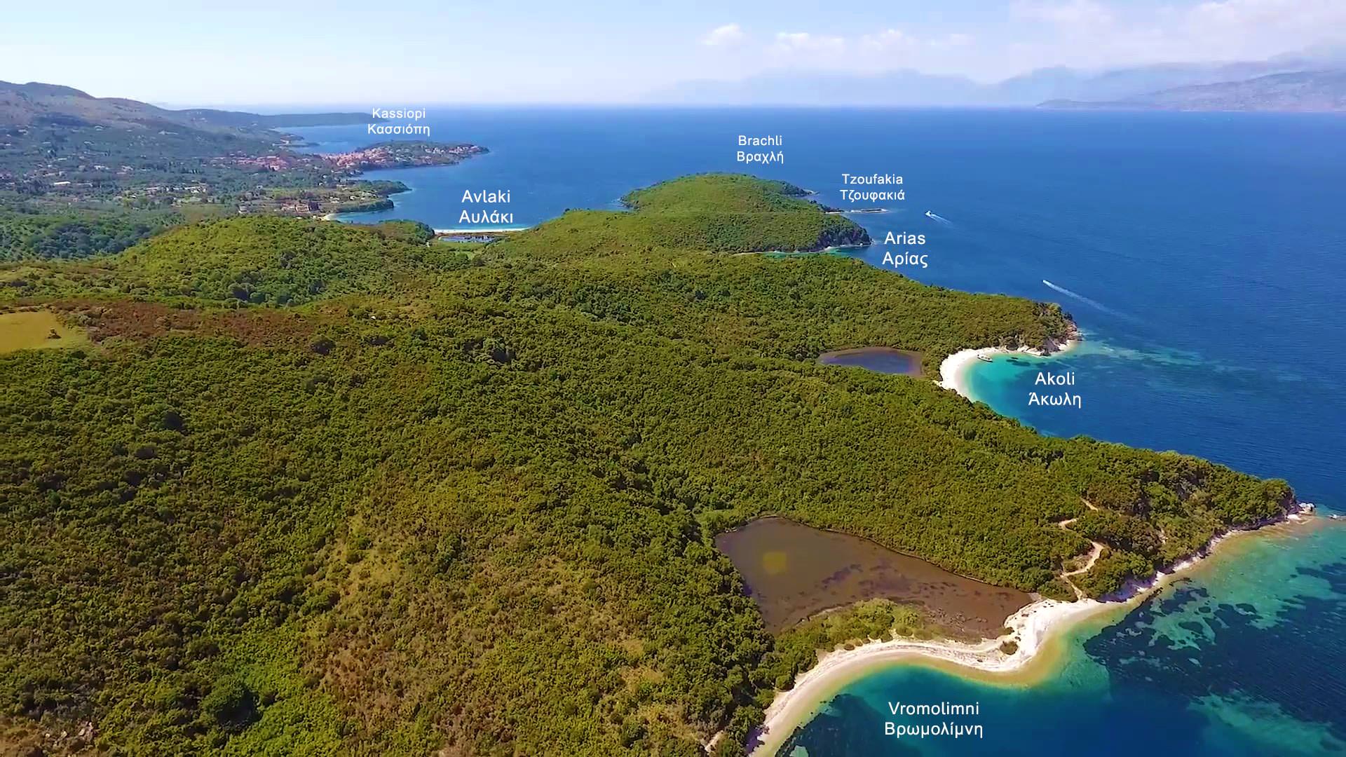
Erimitis area is the Northeastern tip of Corfu island, very close to Albanian shores.
It starts from the Agios Stefanos area in the East and stretches up to Kassiopi borders on the North Coast.
Erimitis’s view of some of the beaches is spot on
An unspoiled paradise is full of small, cute coves separated by small promontories that give beautiful scenery to the landscape.
Every cove here is a small pebble beach of unique beauty, all of which are isolated and can be visited only by sea.
Starting from Kassiopi and going to the east, we find the following cute, tiny beaches: Avlaki, Vouvalomantria Beach, Vrachli Beach, Tzoufakia, the Arias Beach, Akoli, Vromolimni, Kaminakia Beach, Korfovounia, Aspalathras, and Xylokeratia Beach.
Let’s note that all these beaches are pebble and no sand, the waters are extremely clear and clean.
Avlaki beach
Avlaki beach at Erimitis – view from behind
Avlaki is the biggest beach in the area, close to Kassiopi, and in visual contact with it.
It is separated into two parts, the west and the east Avlaki, which is much smaller.
On the east side of the west Avlaki, there is another small lake behind it, which sometimes dries out.
There are some houses and apartments on the western part of the beach, the busiest of all, as it is easily accessible by road.
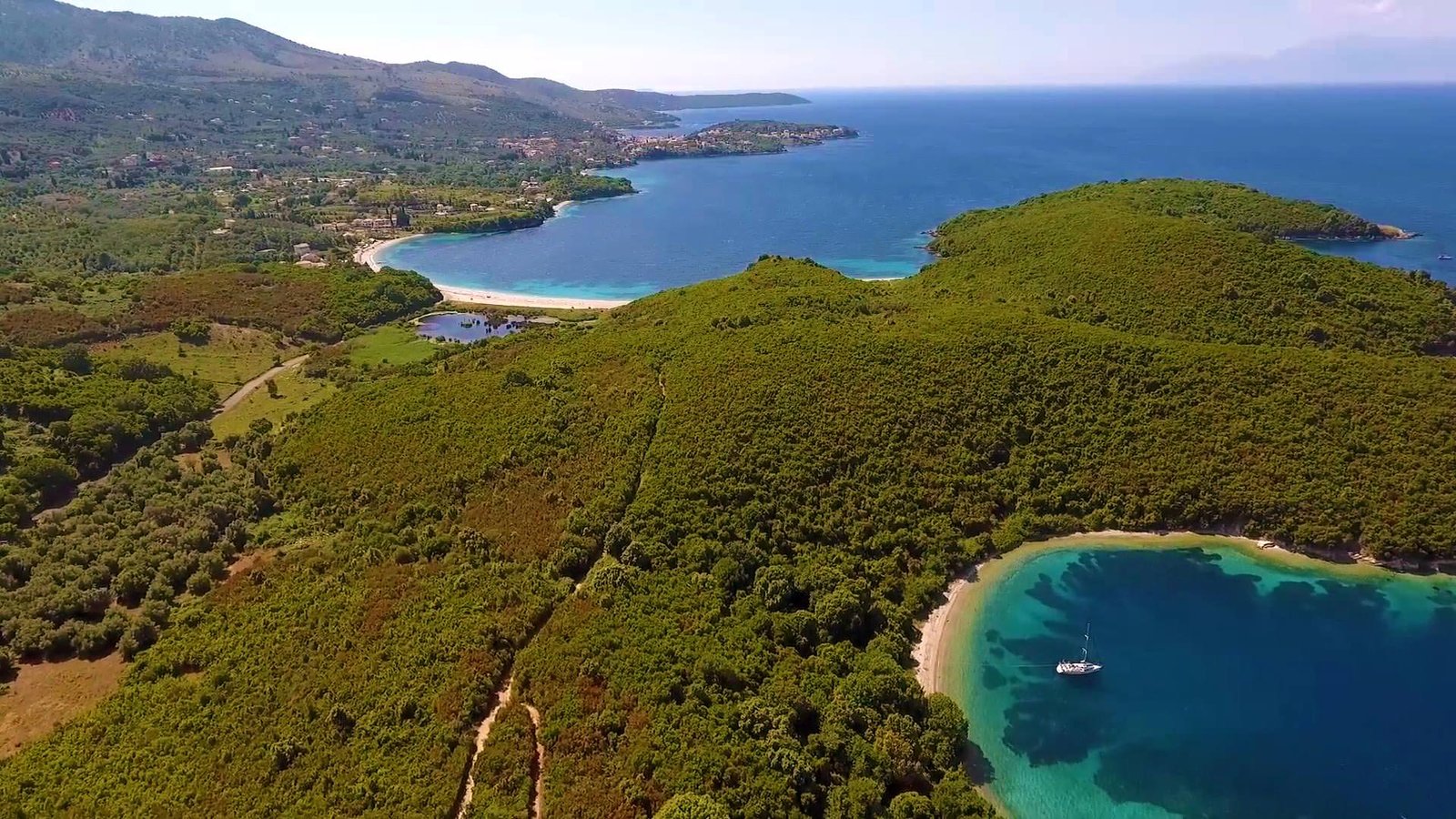
Vouvalomantria beach
At the northern tip of Erimitis, a very small and secluded beach is available only by sea.
Vrachli beach
A Lovely beach facing east, the only one without a small lake behind it.
Tzoufakia beach
A Tiny beach next to and south of Vrachli, completely isolated.
Arias beach
Arias Beach at Erimitis Corfu
Another beauty is the isolated pebble beach a little south of Tzoufakia.
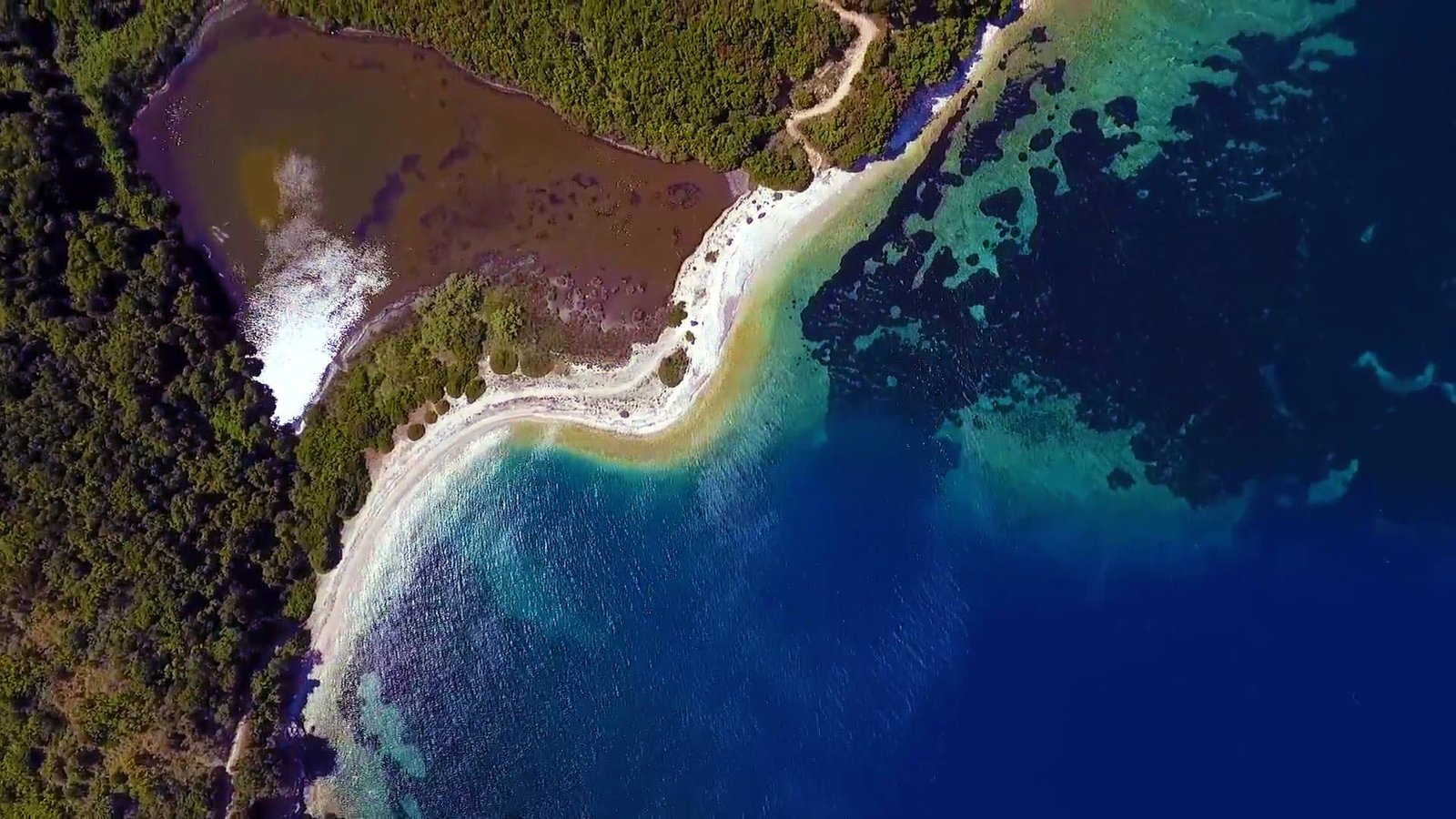
Akoli beach
Akoli beach at Erimitis, Corfu
One of the few beaches in the area is reachable on foot through a small path.
The name is due to the lake behind the beach, which is believed to be very deep.
Although the lake, in reality, is not deep, the name means literally “bottomless”, α-κωλη, in Greek, this is from the deprivation α = χωρίς(without), and the word κώλος, in ancient Greek, κώλος means bottom.
(while in modern Greek means ass.) In this case, the word has an ancient meaning and means bottomless, used for deep seas or lakes.
Vromolimni beach
Vromolimni beach, Erimitis, Corfu
Another beach with a lake behind it, the name “Vromolimni” means Dirty lake, it is dirty indeed compared to the clean waters of the sea.
Kaminakia, Korfovounia, Aspalathras, and Xylokeratia beaches
Between Vromolimni and the small harbor of Agios Stefanos, we find these small diamonds respectively.
All are very tiny and isolated from each other, but can be reached too by small pathways.
This is the real story of the Durrells in Corfu. An eccentric and a little crazy family lived in Corfu from 1936 to 1939 in Kontokali, Kalami, and Perama.
India in the first quarter of the 20th century (1858 – 1947) was ruled by the British Crown. It was known as British Raj, so there were many British military and government officials there.
Laurence Durrel was an army engineer born in India. He met Louisa Florence Dixie, and they got married and made four children. Laurence, Leslie, Margaret, known as Margo, and Gerald, known as Jerry.
Laurence Durrel, the father, died young at age 44 in 1928 due to cerebral hemorrhage. After the unexpected loss of their father, the family had to move to England and to Bournemouth. There the mother, Louise, tried to organize their lives with her small pension.
There, the four-year-old Gerald was sent to school for his basic education. This was difficult for the unpalatable character of the little one. He enjoyed the freedom and his engagement with animals and nature.
It was a very difficult time for young Jerry who could not adapt to the stifling environment of an English school. As he confessed several years later in his autobiography.
Arriving in Corfu
In 1935, the older brother Lawrence marries and along with his wife Nancy moved to Corfu. They lived in a house in Kontokali, north of the town, in Villa Anemogianni.
Louisa Durrell, after six difficult years, decides to overcome. Gathers her three children (Leslie, Margaret, and Gerald) and in 1935 they arrive in Corfu.
The Durrells houses on inter-war Corfu
Inter-War Corfu was a poor island. Without electricity but at a very cheap cost of living compared to the cost in England. The Durrells in Corfu could live a little more primitively but more freely. And in direct connection with nature and the animals that little Jerry loved.
Louisa Florence with Gerald, Margo, and Lawrence Durrell
In Corfu, there were and still living a lot of English people. Louisa met one of them, Mr. Biller, who has undertaken to help her find a suitable home for the family.
But Corfu in 1935 was a little more primitive than Mrs. Durrel expected. This is obvious from the following funny event.
Mr. Biller prepared a list of about 10 houses and started with Mrs. Durrell to check them to find the best one.
But in every house they visited, Mrs. Durrell nodded her head, she could not find anything to please her.
They arrived at the last, and once again Mrs. Durrell was not satisfied. Mr. Billler sits down on the stairs and wipes the sweat with his handkerchief, asking Mrs. Durrell.
-And finally, Mrs. Durrell, can you tell me what exactly are you looking for and why did not you like any of what we saw?
– None of them had a normal bath, she replied, that’s the problem.
– And what do you need the bathroom for?, replied the surprised Mr. Biller, when you have the sea at your feet!
This was Corfu at that time, only the rich families had a toilet. While in most houses there was none. The people for their natural needs used to run to the fields and the sea. The little rubbish was buried in the fields and the yards to become fertilizer.
After some more effort, they finally found a hut belonging to a fishing family in Kalami. A small bay in the northeastern part of the island, far from the town of Corfu.
The cottage was repaired to become home, a house known to date with the name: the white house. It is located near the southern part of the bay overlooking the whole of Kalami.
The house was turned by young Jerry into a zoo, where he had gathered all wildlife of Corfu. Turtles, waterfalls, seagulls, lizards, dogs, cats, donkeys, and whatever animal exists in Corfu. He also collected insects in boxes, a chaotic house where birds were flying from room to room.
During the three years, they lived on the island, the Durrells became friends with the locals. They left their mark in the memories of the older ones who met and are still alive today.
They loved the island and were loved by the locals. They wrote books about Corfu which was considered their paradise.
Much of what we know today about the Durrells in Corfu is based on the narratives of those old residents who are still alive. But mainly on the books written by the family members.
Gerald’s records of Corfu’s fauna are very important. He has recorded almost all the species of animals, birds, and insects on the island in his book “My Family and Other Animals”.
He explored the island and made his observations with the help of a friend of the family. The local doctor, naturalist, and philosopher Theodoros Stefanidis.
Stephanidis is the one who cultivated Jerry’s inborn talent and love for animals. And helped him later develop into a great naturalist and reformer of zoos.
The whole family was skillful writers. In their writings, we read all the incidents and personal experiences they had during their stay on the island. This became also a source of inspiration for the TV series.
The main inspiration source was Gerald’s autobiography book “The Trilogy of Corfu”. Consists of 3 books: “My Family and Other Animals”, “Birds, Animals and Relatives” and the last “The Garden of the Gods”. Another source was Margaret’s book: “What Happened to Margo?”
Lawrence Durrell
Also noteworthy is “Prospero’s Cell” written by the older brother Lawrence.
Gerald Durrell
This eccentric family loved Corfu and wrote about this island. Margarita later revealed that she always considered Corfu as her real home.
There are, of course, many unknown aspects of Darrel’s life on the island. For example, it is not widely known that the family stayed in other parts of the island too, and not only in Kontokali.
In fact, they stayed for a long period in a house in Perama near the Agia Kyriaki area. From there they had easy access to the Halikiopoulos lagoon which at that time was a rich wetland. Since the airport didn’t exist yet.
But the war is always overturning plans and changing everything.
The outbreak of World War II forced Louisa, Leslie, Gerald, and their young Corfiot maid Maria Kontos to leave Corfu. Mainly for safety reasons, and return to Bournemouth, England.
However, the big brother Lawrence remained in Corfu along with his wife Nancy until the occupation of Greece by the Axis forces. Then they managed to escape to Egypt.
Margo remained in Corfu and she stayed in the house of some friends. She met an RAF pilot who was stationed here, his name was Jack Breeze who later became her husband.
The Durrell’s later life
Louisa Florence Durrell, born Louisa Florence Dixie(1886-1964), the mother after the adventure in Corfu settles in Bournemouth until the end of her life in 1964. She lived with her daughter Margo.
Lawrence Durrell (1912-1990), The older brother was a smart man with a restless character. He became a diplomat and a great writer, his books had tremendous success. He traveled all over the world and stayed in many places, he also married 4 times. He died in Sommières, France in 1990.
Leslie Durrell (1918-1983), was the second oldest brother and the least-known member of the family. During his later life, he had a great interest in weapons, hunting, and sailing, as well as painting. He did several business efforts, one of which was to organize a farm in Kenya. But all attempts were unsuccessful. He had a son with his family’s Corfiot maid Maria Kontos who followed him to England.
Margaret Durrell (1920-2007), Known as Margo.
She met an RAF pilot in Corfu just before the arrival of Axis occupying forces. They both fled to South Africa and got married, they stay there until the end of the war. Then they moved to Bournemouth where they had two children and then divorced.
After the divorce, Margo spent the rest of her life in Bournemouth, where she rises alone with her two children, until her death in 2007. She was also a writer and in 1950 she wrote the book “What Happened to Margo?”. With memories from her experience in Corfu. The book was published 40 years later, in 1995.
Margaret or Margo was very dear, and kind, and she was very interested in fashion and design. A very independent and dynamic character.
Gerald Durrell (1925-1995), The younger brother became very successful. He was a popular naturalist, economist, TV presenter, and writer, and his work redefined the role and pattern of the modern zoo.
He also had a good sense of humor. When once someone asked him which animal he liked the most he said: “Do you mean except my wife?”
Finally, he founded the Durrell Wildlife Conservation Trust in Jersey. Now directed by his last wife, Lee McGeorge Durrell.
The Durrells house today
Durrells during their time in Corfu used three houses. Today these houses are private, but the house they lived in Kalami is open to visitors as today it is an apartment. Underneath the house, there is a restaurant called the white house as well.
The Durrells is a very successful British comedy-drama TV series written by Simon Nye and based on The Trilogy of Corfu. An autobiographical book by Gerald Durrell.
The book includes Gerald’s memories of the 4 years the family lived on the island of Corfu shortly before World War II broke out.
Where is the Durrells series filmed?
The series was mainly filmed in Corfu and the studio scenes in London, at Ealing Studios and Twickenham Studios.
The Durrells series was also filmed in spots of Corfu’s old town, In the Palace of Saints Michael and George, at the entrance of the Museum of Asian Art.
Some scenes were filmed in Mon Repos palace, in the Kanoni area, next to the ruins of the ancient city of Corfu.
At the Danilia Village.
In the rich biodiversity of Lake Antinioti on the northern tip of Corfu.
In many other places around the island, some of them being the picturesque port of Agios Stefano’s northeast of the island and Dassia.
The house they used in the series is an old seaside villa in the Kommeno area and not the original property in Kalami where they lived in reality 90 years ago.
Today the house in Kalami is private property and is not open for public visits, but being a small hotel with a taverna operating on its ground floor, you can visit it in another way.
Played on ITV from 2016 to 2019, there were 4 series including 6 episodes each. Only the third series played in 2018 had 8 episodes.
The series was directed by 4 different directors.
Episodes 1, 2, and 3 of the first series – 1, 2, 3 of the second series, and 4, 5, and 6 of the fourth series were directed by Steve Barron
Episodes 4, 5, and 6 of the first series – 1, 2, 3, 4 of the third series, and 1, 2, and 3 of the fourth series were directed by Roger Goldby
Episodes 4, 5, and 6 of the second series were directed by Edward Hall
And episodes 5, 6, 7, and 8 of the third series were directed by Niall MacCormick
A couple of dozens of actors participated in the series, many as guests or in minor roles.
The main characters though were 8 and played by
Keeley Hawes in the role of Louisa Durrell, the family’s mother
Milo Parker in the role of Gerry Durrell, the naturalist
Josh O’Connor as Larry Durrell, the writer
Daisy Waterstone as Margo Durrell
Callum Woodhouse as Leslie Durrell, the least-known brother
Alexis Georgoulis as Spiros Halikiopoulos, the taxi driver
Anna Savva as Lugaretzia
Yorgos Karamihos as Theo Stefanidis, a Greek poet, author, doctor, and naturalist, the friend and mentor of Gerald Durrell
About the “Village” in Danilia where the Durrells TV series was filmed
The “Village” is next to Danilia village, close to Kontokali, and behind today’s Corfu hospital. It is not the revival of an existing village as some people believe.
It was a successful attempt by two businessmen. The Bouas brothers decided in 1980 to create from scratch something that will look like an old typical Corfiot village. To use it as a tourist attraction for their businesses in the 80s.
And, indeed, during the 80s all tour operators organized daily excursions to this medieval and Venetian-style village. With thousands of tourists visiting the place.
Among the other sight-seen, there was an open outside restaurant with live music. Many shops sell souvenirs to visitors. Some museums with objects of folk art and a large building housed the winter restaurant.
On the walls of this building, you could see the escutcheons of all the old noble families of Corfu. Of course, any common sense human could understand immediately that a village like this could never really exist in Corfu.
In this village also you can see that the main street is a replica of a part of Nikiforos Theotokis street in Corfu town. And some other copies of other characteristic shops or scenes were used to give a Venetian color and atmosphere.
So, it is a replica of an alleged village as it would be in 1930, the Village at Danilia never existed in the past, It’s just business!
Today this Village is owned by Grecotel Hotels & Resorts. A large hotelier group, and is used for weddings that happened among Grecotel Hotels & Resorts customers.
Also, it was used as the filming place for many scenes of the Durrells TV series. This series has been going on for three years and includes 6-8 episodes per year.
The TV series has been judged to be very successful in England and will continue for another year. The Next (and last) episodes are already filmed and will be shown on TV in 2019. The last scenes were filmed in Corfu! In the Village, in the white house in Kalami, in Villa Gerakari in Gerekos island, and other places on the island.
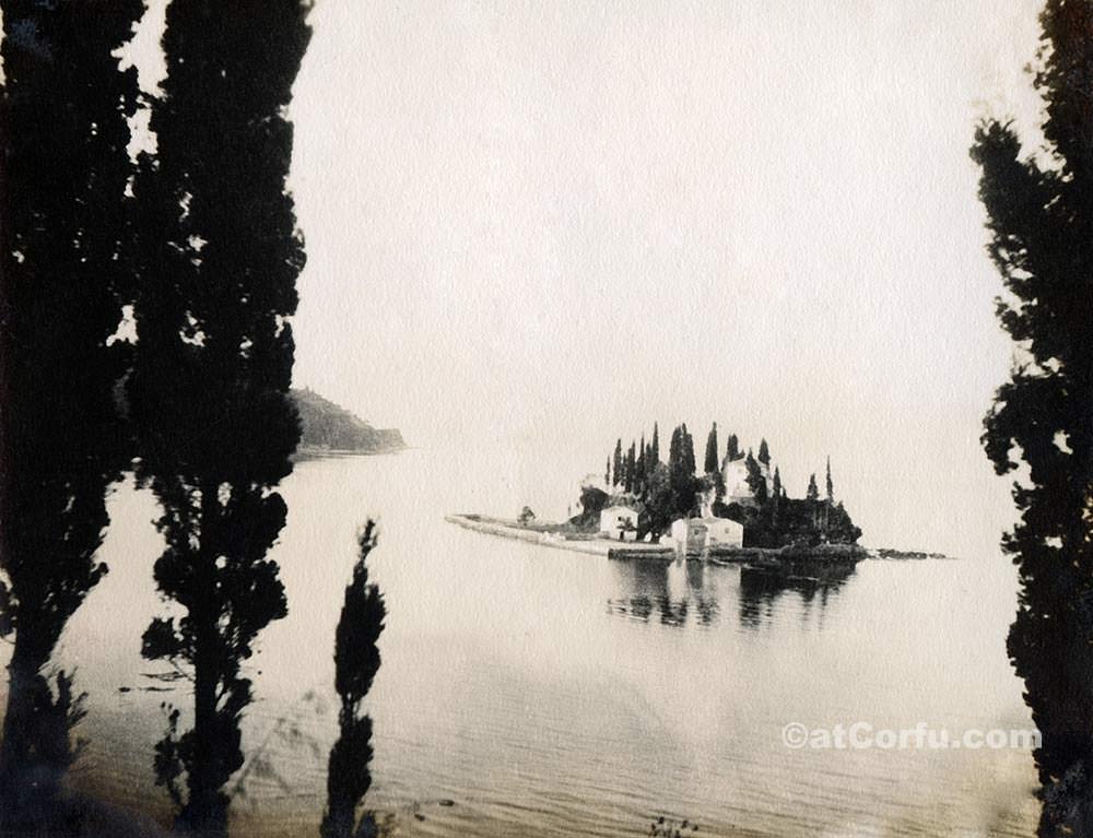
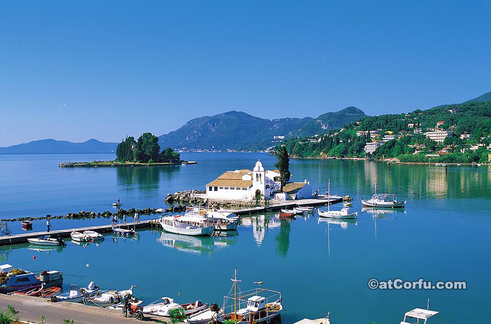
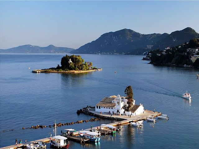
Everybody knows the picturesque Mouse Island or Pontikonisi as the locals call it, at the entrance of the Gulf of Halikiopoulos, in front of the airport runway, along with the neighboring Vlacherna.
It is the most characteristic landscape of Corfu.
Mouse Island is the first thing that every new visitor sees when approaching Corfu airport, it sits literally in the geographical center of the island, very close to the town, between Kanoni peninsula, Perama, and Benitses
On the top of this tiny rocky islet, there is the 11th-century Byzantine Church of Pantokrator surrounded by dense vegetation, It takes some effort to climb the many steps needed to reach the monastery.
Due to the fact that Pantokrator church was actually a monastery with monks, visits to the monastery are restricted except only on the 6th of August, when the Church is celebrating.
But in reality, the church remains open to the public all year round. The rest of the island can be visited at any time via some small boats that sail regularly from the beach below Kanoni and the Vlacherna island.
Today, there are no monks living there, but the gentle staff of a small cafe bar that is on the island. These can be considered as the only residents of Pontikonisi.
This tiny island is a peaceful place, full of greenery, and an ideal spot to relax for a couple of hours. The ticket for the boat to take you there costs no more than 2€
Name’s origin
The name probably came from the size and especially the shape of the island as it looks from above, although in our opinion the island even with a large dose of imagination does not look at all like a mouse.
Another theory says that in the 11th century in the monastery there were many monks from the Pontos area, so in the beginning, the name was Pontonisi which transformed into Pontikonisi, which sounds more convincing about the origin of the name.
The island also resembles a boat, so the following mythological approach suits nicely.
Homer tells in the Odyssey, that Phaecians (The ancient Corfiots) helped Odysseus (Ulysses) to return home to Ithaca transferring him there with one of their boats, the gods became displeased by this and transformed the returning ship into stone when it entered the port and before the sailors could disembark.
This petrified boat according to Greek mythology is the Mouse Island.
However mythology is not reality, Pontikonisi along with next to it Vlacherna which is a flat tiny islet connected with the land via a small bridge, is extremely picturesque and together with the surroundings is the most known scene that since many decades identifies Corfu worldwide.
Vlacherna islet
It is a small islet opposite Pontikonisi and it is connected with Kanoni via a 300-meter small walk path.
On Vlacherna islet there is a Church with a nice high bell tower, devoted to the Virgin Mary, constructed in the 17th century as a replica and named after Panagia Vlacherna in Constantinople.
The Church has an impressive woodcut temple and beautiful frescoes inside.
Vlacherna islet is small, only about half the size of Mouse Island but it looks about the same because most photos are taken from Kanoni which is closer.
We use cookies to offer you a top personalized experience, to help you find more easily what you are looking for, as well as to analyze our traffic. By clicking “Accept”, you consent to the use of ALL the cookies.
This website uses cookies to improve your experience while you navigate through the website. Out of these, the cookies that are categorized as necessary are stored on your browser as they are essential for the working of basic functionalities of the website. We also use third-party cookies that help us analyze and understand how you use this website. These cookies will be stored in your browser only with your consent. You also have the option to opt-out of these cookies. But opting out of some of these cookies may affect your browsing experience.
Necessary cookies are absolutely essential for the website to function properly. These cookies ensure basic functionalities and security features of the website, anonymously.
Cookie
Duration
Description
__cfduid
1 month
The cookie is used by cdn services like CloudFare to identify individual clients behind a shared IP address and apply security settings on a per-client basis. It does not correspond to any user ID in the web application and does not store any personally identifiable information.
cookielawinfo-checbox-analytics
11 months
This cookie is set by GDPR Cookie Consent plugin. The cookie is used to store the user consent for the cookies in the category "Analytics".
cookielawinfo-checbox-functional
11 months
The cookie is set by GDPR cookie consent to record the user consent for the cookies in the category "Functional".
cookielawinfo-checbox-others
11 months
This cookie is set by GDPR Cookie Consent plugin. The cookie is used to store the user consent for the cookies in the category "Other.
cookielawinfo-checkbox-advertisement
1 year
The cookie is set by GDPR cookie consent to record the user consent for the cookies in the category "Advertisement".
cookielawinfo-checkbox-necessary
11 months
This cookie is set by GDPR Cookie Consent plugin. The cookies is used to store the user consent for the cookies in the category "Necessary".
cookielawinfo-checkbox-performance
11 months
This cookie is set by GDPR Cookie Consent plugin. The cookie is used to store the user consent for the cookies in the category "Performance".
viewed_cookie_policy
11 months
The cookie is set by the GDPR Cookie Consent plugin and is used to store whether or not user has consented to the use of cookies. It does not store any personal data.
Functional cookies help to perform certain functionalities like sharing the content of the website on social media platforms, collect feedbacks, and other third-party features.
Cookie
Duration
Description
na_id
1 year 1 month
This cookie is set by Addthis.com to enable sharing of links on social media platforms like Facebook and Twitter
na_rn
1 month
This cookie is used to recognize the visitor upon re-entry. This cookie allows to collect information on user behaviour and allows sharing function provided by Addthis.com
na_sc_e
1 month
This cookie is used to recognize the visitor upon re-entry. This cookie allows to collect information on user behaviour and allows sharing function provided by Addthis.com
na_sr
1 month
This cookie is set by Addthis.com. This cookie is used for sharing of links on social media platforms.
na_srp
1 minute
This cookie is used to recognize the visitor upon re-entry. This cookie allows to collect information on user behaviour and allows sharing function provided by Addthis.com
na_tc
1 year 1 month
This cookie is set by the provider Addthis. This cookie is used for social media sharing tracking service.
ouid
1 year 1 month
The cookie is set by Addthis which enables the content of the website to be shared across different networking and social sharing websites.
Performance cookies are used to understand and analyze the key performance indexes of the website which helps in delivering a better user experience for the visitors.
Cookie
Duration
Description
d
3 months
This cookie tracks anonymous information on how visitors use the website.
YSC
session
This cookies is set by Youtube and is used to track the views of embedded videos.
Analytical cookies are used to understand how visitors interact with the website. These cookies help provide information on metrics the number of visitors, bounce rate, traffic source, etc.
Cookie
Duration
Description
__gads
1 year 24 days
This cookie is set by Google and stored under the name dounleclick.com. This cookie is used to track how many times users see a particular advert which helps in measuring the success of the campaign and calculate the revenue generated by the campaign. These cookies can only be read from the domain that it is set on so it will not track any data while browsing through another sites.
_ga
2 years
This cookie is installed by Google Analytics. The cookie is used to calculate visitor, session, campaign data and keep track of site usage for the site's analytics report. The cookies store information anonymously and assign a randomly generated number to identify unique visitors.
_gid
1 day
This cookie is installed by Google Analytics. The cookie is used to store information of how visitors use a website and helps in creating an analytics report of how the website is doing. The data collected including the number visitors, the source where they have come from, and the pages visted in an anonymous form.
Advertisement cookies are used to provide visitors with relevant ads and marketing campaigns. These cookies track visitors across websites and collect information to provide customized ads.
Cookie
Duration
Description
_pxhd
1 year
This cookie is used by the Zoominfo. This cookie collects information on user behaviour on multiple websites. This information is used inorder to optimize the relevance of advertisements.
CMID
1 year
The cookie is set by CasaleMedia. The cookie is used to collect information about the usage behavior for targeted advertising.
CMPRO
3 months
This cookie is set by Casalemedia and is used for targeted advertisement purposes.
CMPS
3 months
This cookie is set by Casalemedia and is used for targeted advertisement purposes.
CMRUM3
1 year
This cookie is set by Casalemedia and is used for targeted advertisement purposes.
CMST
1 day
The cookie is set by CasaleMedia. The cookie is used to collect information about the usage behavior for targeted advertising.
DSID
1 hour
This cookie is setup by doubleclick.net. This cookie is used by Google to make advertising more engaging to users and are stored under doubleclick.net. It contains an encrypted unique ID.
id
1 year 1 month
The main purpose of this cookie is targeting and advertising. It is used to create a profile of the user's interest and to show relevant ads on their site. This Cookie is set by DoubleClick which is owned by Google.
IDE
1 year 24 days
Used by Google DoubleClick and stores information about how the user uses the website and any other advertisement before visiting the website. This is used to present users with ads that are relevant to them according to the user profile.
KADUSERCOOKIE
3 months
The cookie is set by pubmatic.com for identifying the visitors' website or device from which they visit PubMatic's partners' website.
KTPCACOOKIE
1 day
This cookie is set by pubmatic.com for the purpose of checking if third-party cookies are enabled on the user's website.
mc
1 year 1 month
This cookie is associated with Quantserve to track anonymously how a user interact with the website.
mdata
1 year 1 month
The domain of this cookie is owned by Media Innovation group. This cookie registers a unique ID used to identify a visitor on their revisit inorder to serve them targeted ads.
ov
1 year 1 month
This cookie is set by the provider mookie1.com. This cookie is used for serving the user with relevant content and advertisement.
test_cookie
15 minutes
This cookie is set by doubleclick.net. The purpose of the cookie is to determine if the user's browser supports cookies.
uid
1 year 1 month
This cookie is used to measure the number and behavior of the visitors to the website anonymously. The data includes the number of visits, average duration of the visit on the website, pages visited, etc. for the purpose of better understanding user preferences for targeted advertisments.
uuid2
3 months
This cookies is set by AppNexus. The cookies stores information that helps in distinguishing between devices and browsers. This information us used to select advertisements served by the platform and assess the performance of the advertisement and attribute payment for those advertisements.
VISITOR_INFO1_LIVE
5 months 27 days
This cookie is set by Youtube. Used to track the information of the embedded YouTube videos on a website.