


Last updated on July 4th, 2025 at 10:04 am
Explore a detailed Corfu map to help you navigate the island’s beaches, roads, towns, and attractions.
Below are carefully curated maps in English and Greek to guide your trip effortlessly. We created these maps to provide travelers with all the information they need to explore this island.
🗺️ General Tourist Maps of Corfu Island
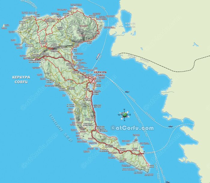
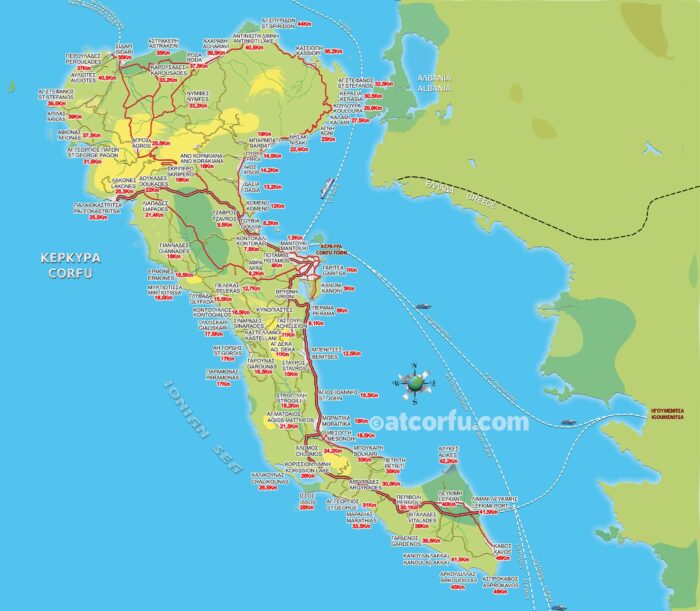
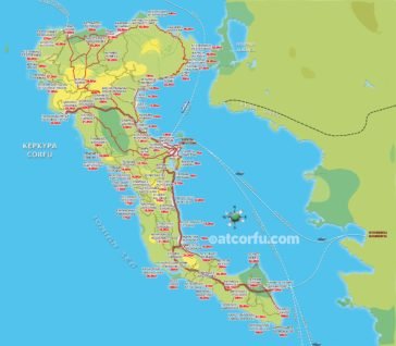
Corfu Island Large Road Map
A comprehensive map of Corfu island showing all major towns, roads, and landmarks with names in both English and Greek — perfect for easy orientation and bilingual travelers.

Tourist Corfu Map Including the Larger Villages
A tourist-friendly map combining the larger points of interest, transportation hubs, beaches, and walking routes, designed to maximize your Corfu experience.
View Full Map
🏛️ Maps of Corfu Town & Old City Walks
The maps of Corfu town were designed with an emphasis on the old city.
A medieval town that essentially formed during the Venetian rule, therefore the streets are narrow with awkward shapes, and actually were and still are for pedestrians. Streets between houses that cannot fit cars.
The only open spot in the old city seems to be the endless Esplanade Square and the area in front of the old fortress, which is rendered with an artistic mood on the map.
The main street of the old town is the street of Nikiforos Theotokis. It starts from Liston and ends at the Spilia, the harbor district at the foot of the New Fortress.
Today, all roads inside the old city are pedestrian roads. The traffic with cars is done on regional routes around the old city.
Corfu Old Town Walking Map

Navigate the charming streets of Corfu Old Town with this detailed walking map, showcasing historic sites, shops, and cafes.
Explore Old Town Map
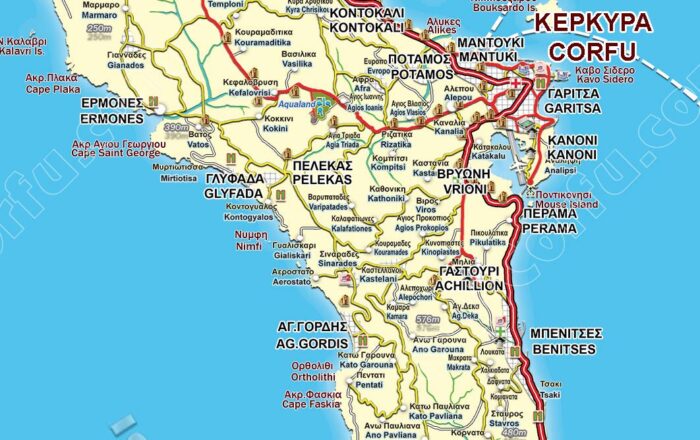
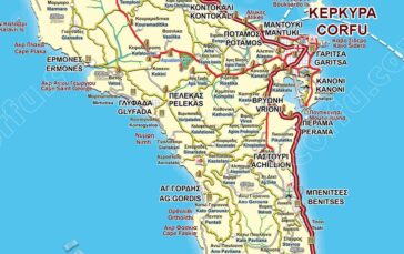
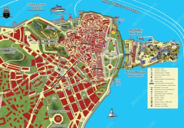
Corfu Town large area road Map

Another map of Corfu’s wider area, including the city’s urban fabric, southern suburbs, and the Kanoni peninsula, extends up to Mouse Island.
See the Map of the Large area of Corfu TownA Large Map of Corfu Town

Focus on Corfu town itself with this detailed city map, perfect for exploring local neighborhoods, landmarks, and amenities.
View Old Corfu Town Map
🏖️ Corfu Beach Maps by Region & Type
Map With the Best Corfu Beaches By Type
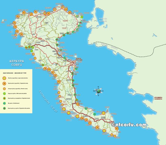
Discover Corfu’s top beaches categorized by type — sandy, pebble, family-friendly, or secluded — so you can pick the perfect spot for your beach day.
Explore the Corfu Beaches Map
Map of Beaches in Corfu Island
An easy-to-follow map highlighting all major beaches on Corfu, ideal for beach lovers wanting to explore the coastline.
View another Beaches Map
Corfu Beaches by Region: Custom Maps of North, South & Central Coasts
🎯 Maps of Attractions, Distances & Directions
Map with Distances and Directions from Corfu Center
Plan your routes efficiently with this map showing driving distances and directions from the Corfu town center to popular destinations across the island.
See Distances and Directions Map
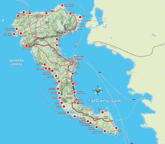
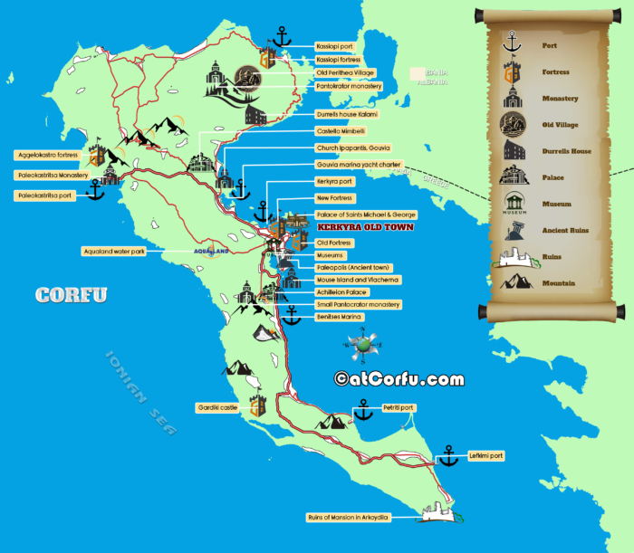
A map of Corfu Attractions, Sights, and Monuments
To open the maps at full size, right-click on the map and open it in a new window or a new tab.
🌐 Interactive Google Map of Corfu
NOTE: You can download and use the maps only for personal use. Reproduction, printing for commercial exploitation, or alteration of the maps is explicitly prohibited.
On your websites, you may use them only if you provide proper credit with a visible link to the source.
➕ More Corfu Maps & Extras
Corfu Beaches by Region: Custom Maps of North, South & Central Coasts
Explore the best beaches by area, using custom regional maps and links to local beach guides all written from firsthand experience.

Map of the City of Corfu With the Southern Suburbs
Another map of Corfu’s wider area, including the city’s urban fabric, southern suburbs, and the Kanoni peninsula, extends up to Mouse Island.
A map of Corfu Attractions, Sights and Monuments
Corfu, with its rich history, stunning landscapes, and vibrant culture, is a treasure trove of attractions waiting to be explored.

Map With Best Corfu Beaches By Type
Explore this map of Corfu beaches, indexing each beach by type. From large sandy shores to secluded pebbly coves, and find the perfect spot for your visit.
Map with Distances and Directions from Corfu center (PDF)
On this map there are Directions to all known villages and tourist places in the island of Corfu and their distance from the center of Corfu

Map of Beaches in Corfu Island
Map with the beaches of Corfu island, the most known small and large beaches around the coastal line of Corfu island.
Corfu Old Town Walking Map
This is another map of Corfu old town

Corfu Island Large Road Map
A large road map of Corfu with all main, large, and rural roads and paths, as they are today.

A Large Map of Corfu Town
A large map of the town of Corfu with emphasis in the old part of the medieval town at the east of the peninsula.
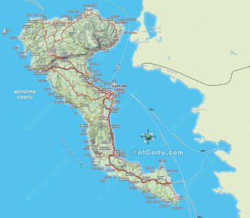
Detailed Tourist Corfu Map
A large map of Corfu island, with all details, and roads, updated every year.
Comments