

📄
Cite this article
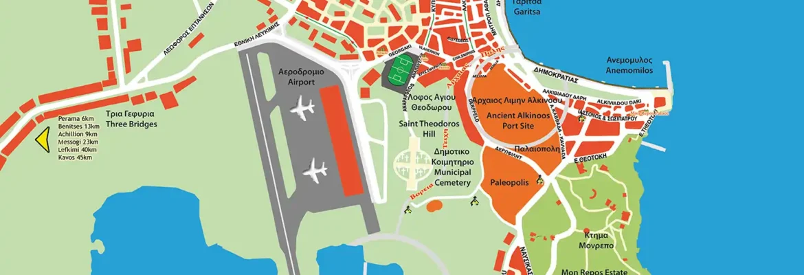
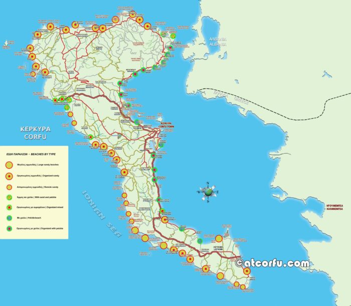
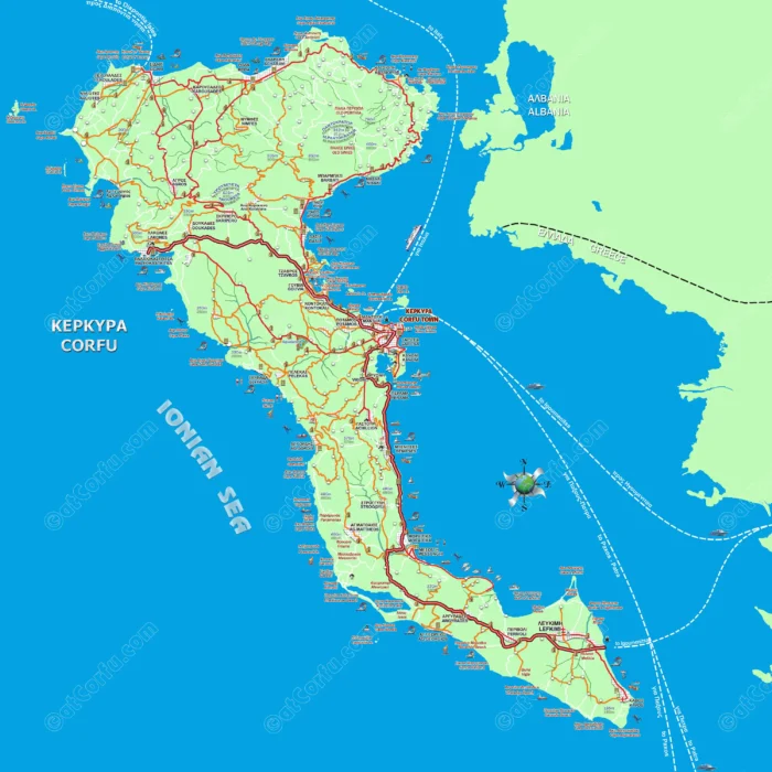
The whole area of Corfu City
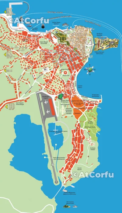
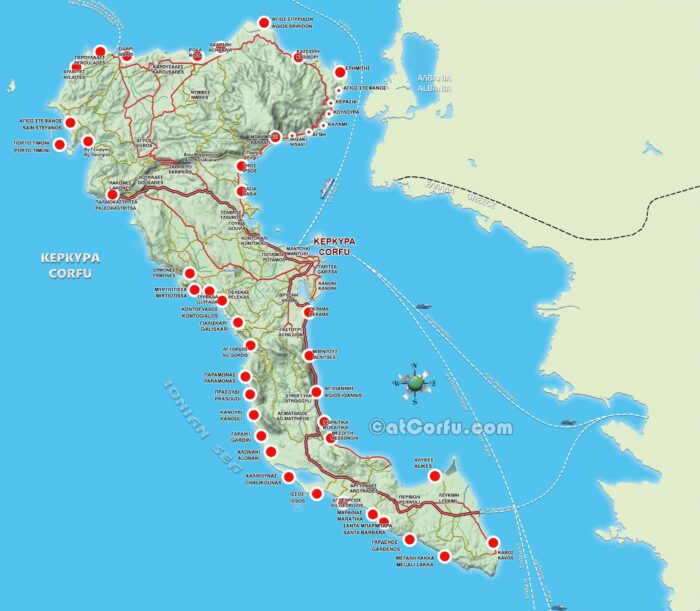
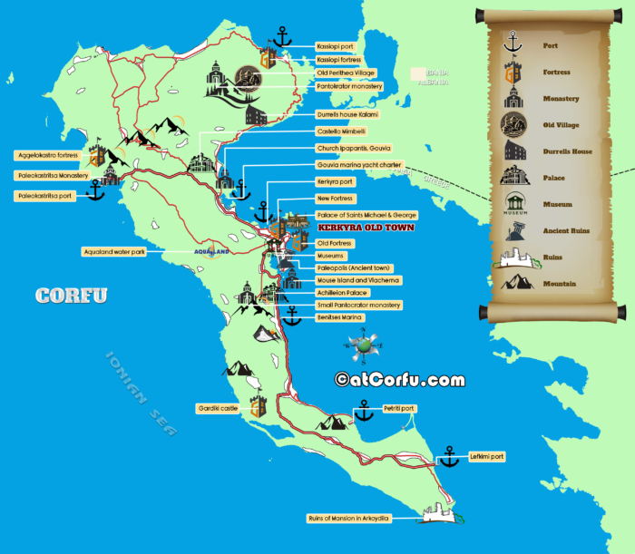
Another map of Corfu’s wider area, including the city’s urban fabric, southern suburbs, and the Kanoni peninsula, extends up to Mouse Island.


Another map of Corfu’s wider area, including the city’s urban fabric, southern suburbs, and the Kanoni peninsula, extends up to Mouse Island.
| Cookie | Duration | Description |
|---|---|---|
| __cfduid | 1 month | The cookie is used by cdn services like CloudFare to identify individual clients behind a shared IP address and apply security settings on a per-client basis. It does not correspond to any user ID in the web application and does not store any personally identifiable information. |
| cookielawinfo-checbox-analytics | 11 months | This cookie is set by GDPR Cookie Consent plugin. The cookie is used to store the user consent for the cookies in the category "Analytics". |
| cookielawinfo-checbox-functional | 11 months | The cookie is set by GDPR cookie consent to record the user consent for the cookies in the category "Functional". |
| cookielawinfo-checbox-others | 11 months | This cookie is set by GDPR Cookie Consent plugin. The cookie is used to store the user consent for the cookies in the category "Other. |
| cookielawinfo-checkbox-advertisement | 1 year | The cookie is set by GDPR cookie consent to record the user consent for the cookies in the category "Advertisement". |
| cookielawinfo-checkbox-necessary | 11 months | This cookie is set by GDPR Cookie Consent plugin. The cookies is used to store the user consent for the cookies in the category "Necessary". |
| cookielawinfo-checkbox-performance | 11 months | This cookie is set by GDPR Cookie Consent plugin. The cookie is used to store the user consent for the cookies in the category "Performance". |
| viewed_cookie_policy | 11 months | The cookie is set by the GDPR Cookie Consent plugin and is used to store whether or not user has consented to the use of cookies. It does not store any personal data. |
| Cookie | Duration | Description |
|---|---|---|
| na_id | 1 year 1 month | This cookie is set by Addthis.com to enable sharing of links on social media platforms like Facebook and Twitter |
| na_rn | 1 month | This cookie is used to recognize the visitor upon re-entry. This cookie allows to collect information on user behaviour and allows sharing function provided by Addthis.com |
| na_sc_e | 1 month | This cookie is used to recognize the visitor upon re-entry. This cookie allows to collect information on user behaviour and allows sharing function provided by Addthis.com |
| na_sr | 1 month | This cookie is set by Addthis.com. This cookie is used for sharing of links on social media platforms. |
| na_srp | 1 minute | This cookie is used to recognize the visitor upon re-entry. This cookie allows to collect information on user behaviour and allows sharing function provided by Addthis.com |
| na_tc | 1 year 1 month | This cookie is set by the provider Addthis. This cookie is used for social media sharing tracking service. |
| ouid | 1 year 1 month | The cookie is set by Addthis which enables the content of the website to be shared across different networking and social sharing websites. |
| Cookie | Duration | Description |
|---|---|---|
| d | 3 months | This cookie tracks anonymous information on how visitors use the website. |
| YSC | session | This cookies is set by Youtube and is used to track the views of embedded videos. |
| Cookie | Duration | Description |
|---|---|---|
| __gads | 1 year 24 days | This cookie is set by Google and stored under the name dounleclick.com. This cookie is used to track how many times users see a particular advert which helps in measuring the success of the campaign and calculate the revenue generated by the campaign. These cookies can only be read from the domain that it is set on so it will not track any data while browsing through another sites. |
| _ga | 2 years | This cookie is installed by Google Analytics. The cookie is used to calculate visitor, session, campaign data and keep track of site usage for the site's analytics report. The cookies store information anonymously and assign a randomly generated number to identify unique visitors. |
| _gid | 1 day | This cookie is installed by Google Analytics. The cookie is used to store information of how visitors use a website and helps in creating an analytics report of how the website is doing. The data collected including the number visitors, the source where they have come from, and the pages visted in an anonymous form. |
| Cookie | Duration | Description |
|---|---|---|
| _pxhd | 1 year | This cookie is used by the Zoominfo. This cookie collects information on user behaviour on multiple websites. This information is used inorder to optimize the relevance of advertisements. |
| CMID | 1 year | The cookie is set by CasaleMedia. The cookie is used to collect information about the usage behavior for targeted advertising. |
| CMPRO | 3 months | This cookie is set by Casalemedia and is used for targeted advertisement purposes. |
| CMPS | 3 months | This cookie is set by Casalemedia and is used for targeted advertisement purposes. |
| CMRUM3 | 1 year | This cookie is set by Casalemedia and is used for targeted advertisement purposes. |
| CMST | 1 day | The cookie is set by CasaleMedia. The cookie is used to collect information about the usage behavior for targeted advertising. |
| DSID | 1 hour | This cookie is setup by doubleclick.net. This cookie is used by Google to make advertising more engaging to users and are stored under doubleclick.net. It contains an encrypted unique ID. |
| id | 1 year 1 month | The main purpose of this cookie is targeting and advertising. It is used to create a profile of the user's interest and to show relevant ads on their site. This Cookie is set by DoubleClick which is owned by Google. |
| IDE | 1 year 24 days | Used by Google DoubleClick and stores information about how the user uses the website and any other advertisement before visiting the website. This is used to present users with ads that are relevant to them according to the user profile. |
| KADUSERCOOKIE | 3 months | The cookie is set by pubmatic.com for identifying the visitors' website or device from which they visit PubMatic's partners' website. |
| KTPCACOOKIE | 1 day | This cookie is set by pubmatic.com for the purpose of checking if third-party cookies are enabled on the user's website. |
| mc | 1 year 1 month | This cookie is associated with Quantserve to track anonymously how a user interact with the website. |
| mdata | 1 year 1 month | The domain of this cookie is owned by Media Innovation group. This cookie registers a unique ID used to identify a visitor on their revisit inorder to serve them targeted ads. |
| ov | 1 year 1 month | This cookie is set by the provider mookie1.com. This cookie is used for serving the user with relevant content and advertisement. |
| test_cookie | 15 minutes | This cookie is set by doubleclick.net. The purpose of the cookie is to determine if the user's browser supports cookies. |
| uid | 1 year 1 month | This cookie is used to measure the number and behavior of the visitors to the website anonymously. The data includes the number of visits, average duration of the visit on the website, pages visited, etc. for the purpose of better understanding user preferences for targeted advertisments. |
| uuid2 | 3 months | This cookies is set by AppNexus. The cookies stores information that helps in distinguishing between devices and browsers. This information us used to select advertisements served by the platform and assess the performance of the advertisement and attribute payment for those advertisements. |
| VISITOR_INFO1_LIVE | 5 months 27 days | This cookie is set by Youtube. Used to track the information of the embedded YouTube videos on a website. |
| Cookie | Duration | Description |
|---|---|---|
| __cflb | 23 hours | This cookie is used by Cloudfare for load balancing. |
| _gat_gtag_UA_26198381_19 | 1 minute | No description |
| anj | 3 months | No description |
| bkng | 5 years | The cookie is set by Booking.com. The exact purpose of the cookie is not known yet. |
| CONSENT | 16 years 8 months 5 days 5 hours 14 minutes | No description |
| essentials_visitor | No description | |
| FCCDCF | 12 hours | No description |
| gadsTest | session | No description |
| i | 1 year | The purpose of the cookie is not known yet. |
| tj_conf | 1 month | No description |
| tj_lb | past | No description |
| tj_seed | 1 year | No description |
| tj_track | 1 month | No description |

Comments